How GPS knows where you are
A GPS receiver never asks anything and is never answered. It listens to four clocks in the sky, works out how late each one sounds, and turns that into a point on the ground. Here is the argument, one step at a time.
Scroll to move the model. Drag it sideways to look around.
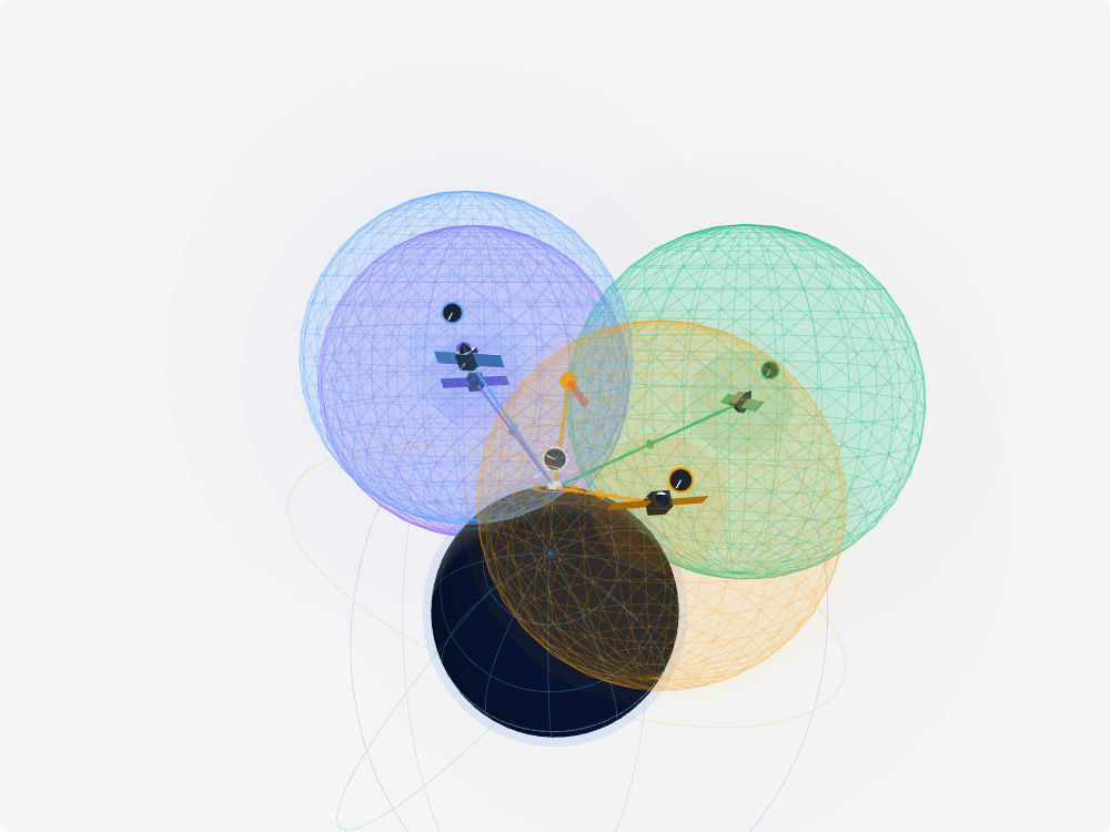
Satellites broadcast the time
-
01
Satellites broadcast the time
Every GPS satellite carries atomic clocks and does one thing forever: transmit who it is, what time it is, and where in orbit it is. It radiates in all directions from about 20,200 km up, and it has no idea you exist. There is no conversation here, only a signal leaving.
-
02
Your phone only listens
Nothing ever goes back up. Your phone asks for nothing and is answered by nobody — it could not reach a satellite 20,200 km away if it tried. Which is why one satellite serves ten receivers or ten billion identically, and why the system has no idea where you are.
-
03
Sent at, arrived at
Written inside the message is the time it left the satellite. Your phone reads that stamp and compares it with its own clock at the moment it arrived. Two numbers, departure and arrival, and that is the whole measurement.
-
04
Delay is distance
The gap between those two numbers is how long the signal spent in flight. Radio travels about 300,000 km every second, so multiplying the delay by that turns a time into a length: 67 milliseconds late is roughly 20,000 km of travel. Nothing about GPS measures an angle to anything — only how late things sound.
-
05
One range is a sphere
A distance says how far, never which way. Every point that far from the satellite fits the measurement equally well, and those points form a sphere around it. You are somewhere on that surface — anywhere on it.
-
06
Two spheres, one circle
Time a second satellite and you get a second sphere. Two overlapping spheres meet along a circle, and you have to be on it, because only those points fit both measurements at once. The whole skin of a sphere has collapsed to one ring.
-
07
Three spheres, two points
A third sphere cuts that ring, and a sphere cutting a circle leaves two points. One of them is thousands of kilometres out in space, where no phone has ever been. Discard it and a single point is left, which is you.
-
08
Your quartz clock is wrong
All of that assumed your phone knew the time, and it does not: it runs on a quartz crystal worth a few cents, not on caesium. One microsecond of error is 300 m of error in a range — and it is the same error, at the same instant, in every range at once, because one clock timed them all. Three biased spheres still meet neatly, just not where you are.
-
09
One bias, four equations
That "at once" is the way out: the offset is one shared unknown, not four separate mistakes. Three coordinates plus one clock error make four unknowns, a fourth satellite makes the fourth equation, and the receiver solves position and time together in a single step. That is why the clock on your phone is exact, and why it came free.
Your phone doesn’t talk to the satellites
This is the part almost everyone has backwards. GPS is receive-only. The satellite transmits, your phone listens, and nothing goes back up. Your phone could not reach a satellite 20,200 km away even if it wanted to — the signal arriving at the ground is weaker than the thermal noise around it, and the only reason it can be read at all is that the receiver knows the exact code to correlate against.
Two consequences follow from that, and both are why GPS works the way it does. There is no limit on the number of users: one satellite serves ten receivers or ten billion identically, because it is doing the same thing either way. And the system cannot see you. Location tracking on a phone is the phone deciding to send its position somewhere over the mobile network — a completely separate act, on a completely separate radio.
Why it’s a pseudorange and not a distance
A receiver measures a delay and multiplies by the speed of light. Call the result a distance and you have quietly assumed your own clock is right, and it is not. Light travels about 30 cm in a nanosecond, so a clock error of a single microsecond throws every range off by 300 m. No consumer device carries a clock anywhere near that good.
So the measurement gets an honest name. A pseudorange is the true range plus whatever your clock is out by, and the error is the same on every satellite in the same instant, because it is one clock making it. That turns a disaster into an unknown: three coordinates and one clock offset, four unknowns, four satellites, one solve. The receiver does not correct its clock and then find its position — it finds both at the same time, from the same four equations.
Which is why the time on your phone is better than the time on almost anything else you own. It falls out of the navigation solution for free.
Relativity is not a footnote
The satellite clocks and the ground clocks do not run at the same rate, and the difference is large enough to break the system in an afternoon.
Two effects pull in opposite directions. The satellites are moving at about 3.9 km/s, and special relativity says a moving clock ticks slow: roughly 7 microseconds a day lost. They also orbit at four Earth radii from the centre, well up out of the gravity well, and general relativity says a clock higher in a gravitational field ticks fast: roughly 45 microseconds a day gained. The net is about 38 microseconds a day fast.
At 300 m per microsecond, ignoring that would walk your position off by more than 10 km a day. The correction is not a software patch either — the onboard oscillators are deliberately built to run at 10.22999999543 MHz instead of a round 10.23 MHz, so that once they are in orbit they tick at the right rate as seen from the ground. General relativity is engineered into the hardware of something a billion people carry in a pocket.
What the model leaves out
The scene compresses the scale badly, and it has to. Real GPS orbits at 4.2 Earth radii; here the satellites sit at about 2.2, or the spheres would not fit on screen. The orbital planes are spread for legibility rather than matching the six real ones.
The bigger omission is that clean geometry is not what a receiver actually faces. The signal slows down crossing the ionosphere and the troposphere by up to tens of metres of apparent range, corrected either from a broadcast model or by comparing two frequencies. It bounces off buildings and arrives twice, which is why a city centre is so much worse than a field. And a real receiver rarely uses exactly four satellites: it uses every one it can see, eight or twelve or more, and solves the overdetermined system by least squares rather than the exact intersection drawn here. Four is the minimum, not the method.
The model also draws one constellation. Your phone is almost certainly tracking GPS, Galileo, GLONASS and BeiDou at once — well over a hundred satellites between them — which is most of why a modern fix is quick and holds up in places where GPS alone used to give up.
The parts
- Trilateration
- Finding a position from distances to known points. Not triangulation, which uses angles — GPS never measures an angle to anything.
- Atomic clock
- A clock disciplined by an atomic transition rather than a vibrating crystal. Each GPS satellite carries several caesium or rubidium standards, good to a few nanoseconds a day.
- Pseudorange
- The raw satellite-to-receiver distance a receiver computes from the measured delay. It is not the true range, because it still contains the receiver's own clock error.
- Clock bias
- How far the receiver's clock is out from GPS time. It shifts every pseudorange by the same amount, which is exactly what makes it solvable as a fourth unknown.
- Ephemeris
- The precise orbit data a satellite broadcasts about itself, so the receiver knows where the sphere is centred. Valid for a few hours; the coarser, longer-lived version for the whole constellation is the almanac.
- Constellation
- The full set of satellites in one system. GPS keeps at least 24 in six orbital planes inclined 55 degrees, usually flying 31, so that four or more are above the horizon anywhere on Earth.
- Time to first fix
- How long a receiver takes to produce a position from cold. It has to download ephemeris data at 50 bits per second, which is why a cold start takes tens of seconds and a warm one is instant.
- GNSS
- Global Navigation Satellite System, the generic term. GPS is the American one; Galileo, GLONASS and BeiDou are the European, Russian and Chinese ones. Your phone uses several at once.
- Selective availability
- Deliberate degradation of the civilian signal by the US military, which held everyday accuracy to about 100 m. Switched off in May 2000, and the satellites built since do not have the capability at all.